Governor Mike Dunleavy has issued an emergency for spring floods in response to historic breakup flooding along the Kuskokwim River. This declaration allows eligible communities and individuals to access state funds for emergency-related expenses and receive assistance.
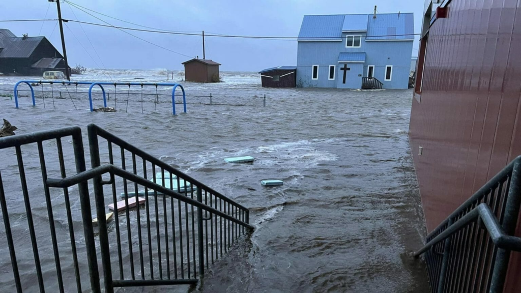
Numerous communities along the lower Kuskokwim River remain submerged in icy water.
The Kuskokwim River carved a passage through a troublesome ice jam downstream of Bethel, resulting in a slight decrease in water levels. However, reports indicate that the area re-blocked on May 10, exacerbating Napaskiak, Oscarville, and Bethel flooding. Upstream, Kwethluk continues to grapple with flood impacts.
On May 10, Hydrometeorologist Kyle Van Peursem from the National Weather Service appeared on KYUK’s morning show, “Coffee at KYUK.”
Van Peursem emphasized that the situation will not improve until the ice jam moves downstream, and it may even worsen.
A flood warning is active for the Kuskokwim River, Brown’s Slough, and adjacent areas until Monday morning, May 13. Additionally, Kwethluk is under a flood warning until midday on May 13.
About 6 miles downstream from Bethel, Napaskiak is facing ongoing water threats, with the community’s airport now isolated as an island accessible only by boat across a roughly half-mile stretch of water, according to resident Earl Samuelson.
As of May 10, Samuelson reported that water had inundated all low-lying areas in the community and was within 8 to 10 inches of flooding some homes, marking the highest water levels seen in Napaskiak since 1995.
“Folks traveling by boat should be mindful of minimizing wake near the town, as these homes are currently in a critical situation,” Samuelson advised.
Governor Dunleavy’s declaration highlights the significant impact of spring floods, including the severe flooding along the Kuskokwim River, which has affected many communities in the region.
He also mentioned that the Napaskiak school is prepared to serve as an evacuation shelter if necessary.
“For those considering going to the school, it’s advisable to have a day pack or backpack with extra food for a couple of days, water, medications, and essential belongings,” Samuelson suggested. “Now might be a good time to prepare in case we need to initiate an evacuation or temporary stay at the school.”
Van Peursem noted that slight fluctuations in the river level do not necessarily indicate the beginning of the ice jam breaking up.
“We’ve observed in the last 24 hours that the river level has been fluctuating, sometimes rising, then dropping slightly. There’s no indication of a significant drop until the ice jam breaks,” Van Peursem explained. “Therefore, anticipate continued flooding in Bethel and surrounding areas for at least the next day, if not longer.”
On May 10, Bethel’s city government announced that areas affected by flooding would not have access to hauled water services until the river water recedes. This includes Main Street, Second through Seventh Avenues, Bridge Street, Tundra Street, Alder, East Avenue, Hangar Lake, and Osier Avenue.
As of 11 a.m. on May 10, water levels at the Brown’s Slough gauge in Bethel remained at 11.48 feet, marking the highest levels in decades and nearing the threshold of moderate flooding, which may necessitate the evacuation of some homes. On May 9, the city advised residents to brace for worsening conditions and cautioned against vehicles approaching the seawall due to soft and hazardous conditions.
Upstream, Kwethluk continues to grapple with the most severe flooding witnessed thus far this breakup season. As of last night, officials reported a 1 to 2-foot increase in flooding within the community.
“The Kwethluk River is completely flooded. When we flew up, the river was indiscernible because the entire tundra was submerged,” Van Peursem remarked. “However, we received news this morning indicating that water levels appear to be stabilizing, which is a positive indication. It seems like things are moving in the right direction for them. Hopefully, we have reached the peak in terms of water levels.”
Van Peursem also noted that the ice appears to be deteriorating below Napakiak and toward the Johnson River. He explained that based on the movement or lack thereof of the jam, residents can anticipate at least another 24 hours of increasing water levels.


